Tropical Storm Francine to Intensify into Hurricane: U.S. Gulf Coast on Alert
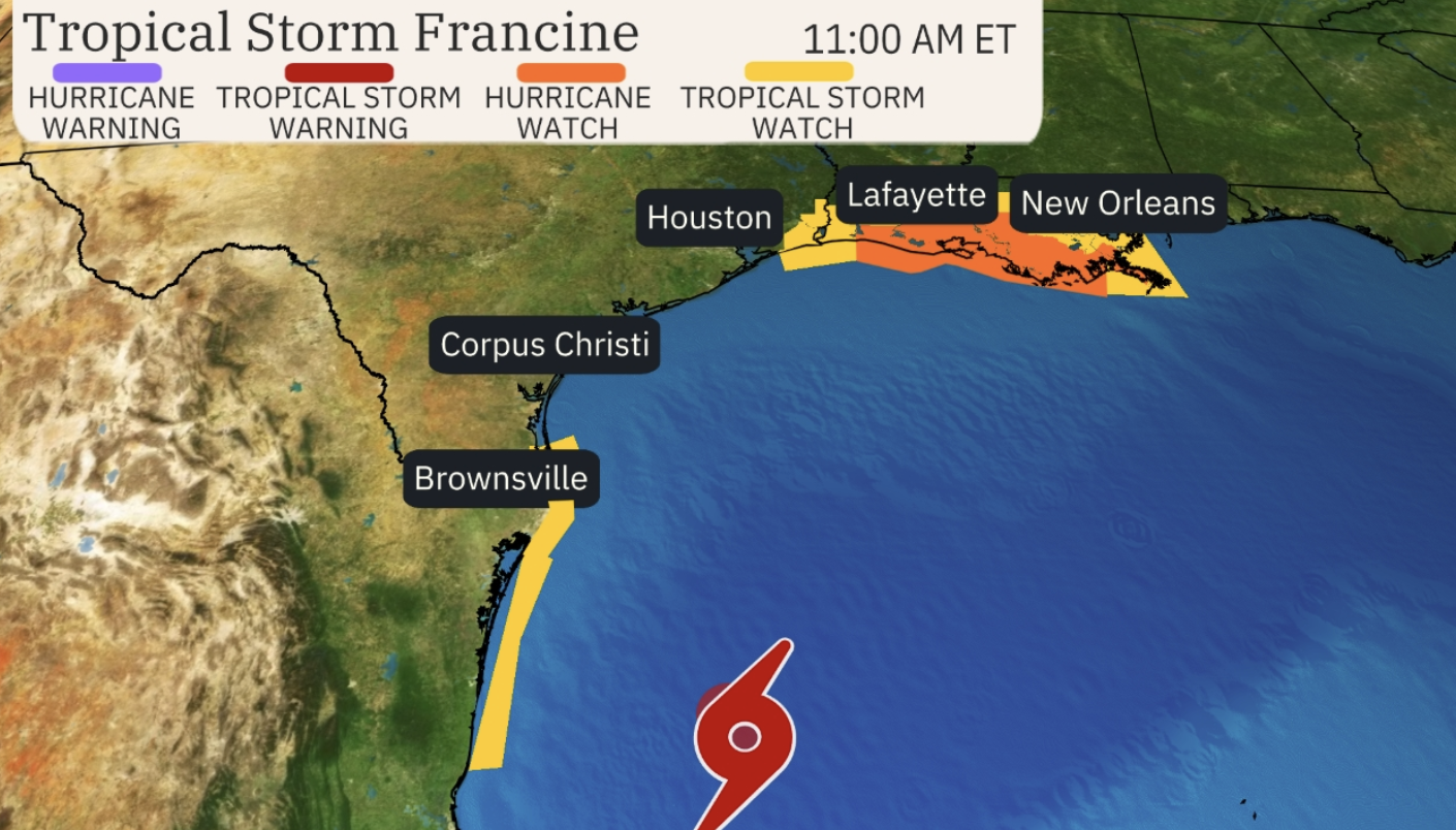
The U.S. Gulf Coast is bracing for the arrival of Tropical Storm Francine, which is forecasted to strengthen into a hurricane by midweek. With a hurricane watch already issued for nearly the entire Louisiana coastline, from Cameron to Grand Isle, residents are urged to stay prepared as the storm intensifies.
Current Status and Path of Tropical Storm Francine
As of now, Tropical Storm Francine is positioned approximately 245 miles southeast of the mouth of the Rio Grande, in the Gulf of Mexico. According to the National Hurricane Center (NHC), the storm is moving north-northwest at 5 mph, with sustained winds of 50 mph and higher gusts. Francine is expected to continue its northwestern track, passing offshore of the northern Gulf of Mexico by Tuesday. By Wednesday, it will likely approach the coastlines of Louisiana and upper Texas.
“Francine is expected to become a hurricane before it reaches the northwestern U.S. Gulf Coast on Wednesday,” stated the NHC in its latest advisory.

Hurricane Watch in Effect for Louisiana Coastline
A hurricane watch has been issued for most of Louisiana’s coastline, extending from Cameron to Grand Isle. As the storm progresses, forecasters anticipate heavy rainfall, significant storm surge, and dangerous winds that could impact southern Texas, southern Louisiana, southern Mississippi, and the far northeast coast of Mexico.
The NHC forecasts that Francine will bring between 4 to 12 inches of rain across these regions. The potential for flash flooding is high, particularly in low-lying coastal areas, as the storm makes its way inland. Additionally, storm surge levels are expected to rise, posing serious flooding risks for those along the coast.
Storm Surge and Coastal Impacts
“The combination of a dangerous storm surge and the tide will cause normally dry areas near the coast to be flooded by rising waters moving inland from the shoreline,” the NHC warned. The deepest waters are expected along the coastline, which will be accompanied by large and dangerous waves, increasing the risk of coastal flooding.
The Louisiana coast, particularly from Cameron to Port Fourchon, could experience storm surges of 5 to 10 feet, while the area extending from Cameron to High Island, Texas, could see surges ranging from 3 to 5 feet. The NHC has also issued a storm surge watch for High Island, Texas, extending to the Mississippi-Alabama border, including Vermilion Bay, Lake Maurepas, and Lake Pontchartrain in Louisiana.
A Busy 2024 Atlantic Hurricane Season
As Tropical Storm Francine gathers strength, it marks the sixth named storm of the 2024 Atlantic hurricane season, which began in June and will run through November 30. So far, the season has seen five named storms, three of which became hurricanes. Most notably, August saw lower-than-expected tropical activity, with only a few named storms, including Debby and Ernesto, both of which became hurricanes before making landfall.
Debby made its mark in early August when it struck Florida’s Big Bend region as a Category 1 hurricane before moving offshore and hitting South Carolina as a tropical storm. Ernesto, another Category 1 hurricane, passed over Bermuda in mid-August, bringing significant wind and rain to the island.
NOAA’s Forecast for Above-Normal Hurricane Activity
The National Oceanic and Atmospheric Administration (NOAA) had predicted an above-normal hurricane season for the Atlantic basin in 2024. The forecast projected 17 to 25 total named storms with winds of 39 mph or higher, out of which eight to 13 are expected to become hurricanes.
Several factors are driving this increased activity, including near-record warm ocean temperatures in the Atlantic, La Niña conditions in the Pacific, reduced Atlantic trade winds, and decreased wind shear. These conditions create an environment that favors the formation and strengthening of storms like Francine, with the potential for significant impacts along the U.S. Gulf Coast.
Preparing for Francine’s Impact
With Tropical Storm Francine forecasted to become a hurricane, residents along the Gulf Coast, particularly in Louisiana and Texas, should stay vigilant. The combination of heavy rain, strong winds, and dangerous storm surge poses a threat to coastal and inland areas. Emergency preparedness measures, including securing property and planning for potential evacuations, are crucial to ensuring safety in the days ahead.
As Francine continues to approach, the NHC will provide updates on the storm’s progression and potential impact. Stay tuned for the latest weather advisories and be prepared for the storm’s potential landfall by midweek.


